Enregistrez gratuitement cette image
en 800 pixels pour usage maquette
(click droit, Enregistrer l'image sous...)
|
|
Réf : V02133
Thème :
Terre vue de l'espace - Iles - Récifs (286 images)
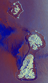
Titre : Bora Bora, French Polynesia
Description : (La description de cette image n'existe qu'en anglais)
This radar image shows three of the Society Islands located 220 kilometers (136 miles) northwest of Tahiti in French Polynesia in the south Pacific ocean. The twin islands in the center of the image, Raiatea (south, lower island) and Tahaa (north, the upper island) share a common lagoon fringed by a coral reef, which appears as the thin bright line surrounding both islands. Bora Bora, the island to the northwest (top of image) is also fringed by a coral reef. The deep bay on the eastern side of Raiatea (right side of image) is fed by the Faaroa River, the only navigable river in French Polynesia. The volcanoes which created these islands were active 3 to 4 million years ago. The two 'motus' (islands) southwest of Bora Bora, within the fringing coral reef, are remnants of the volcanic caldera rim that remain above sea level. Ocean swell caused by trade winds are seen as the small ripples on the ocean surface around all of the islands. The local winds were blowing from east to west (right to left) when these data were collected; large dark areas are areas of low wind while the dark narrow bands just inside much of the reef likely indicate very shallow reef zones. In addition to geological studies, scientists can use such images to study the extent and condition of coral reefs. The area shown is 39 by 67 kilometers (24 by 41 miles); north is towards the upper right. Colors are assigned to the different radar frequencies and polarizations as follows: red is L-band vertically transmitted, vertically received; green is C-band vertically transmitted, vertically received; and blue is the difference between red and green. The image was acquired by the Spaceborne Imaging Radar- C/X-band Synthetic Aperture (SIR-C/X-SAR) imaging radar when it flew aboard the space shuttle Endeavour on October 4, 1994. SIR- C/X-SAR, a joint mission of the German, Italian, and United States space agencies, is part of NASA's Mission to Planet Earth.
|
|

